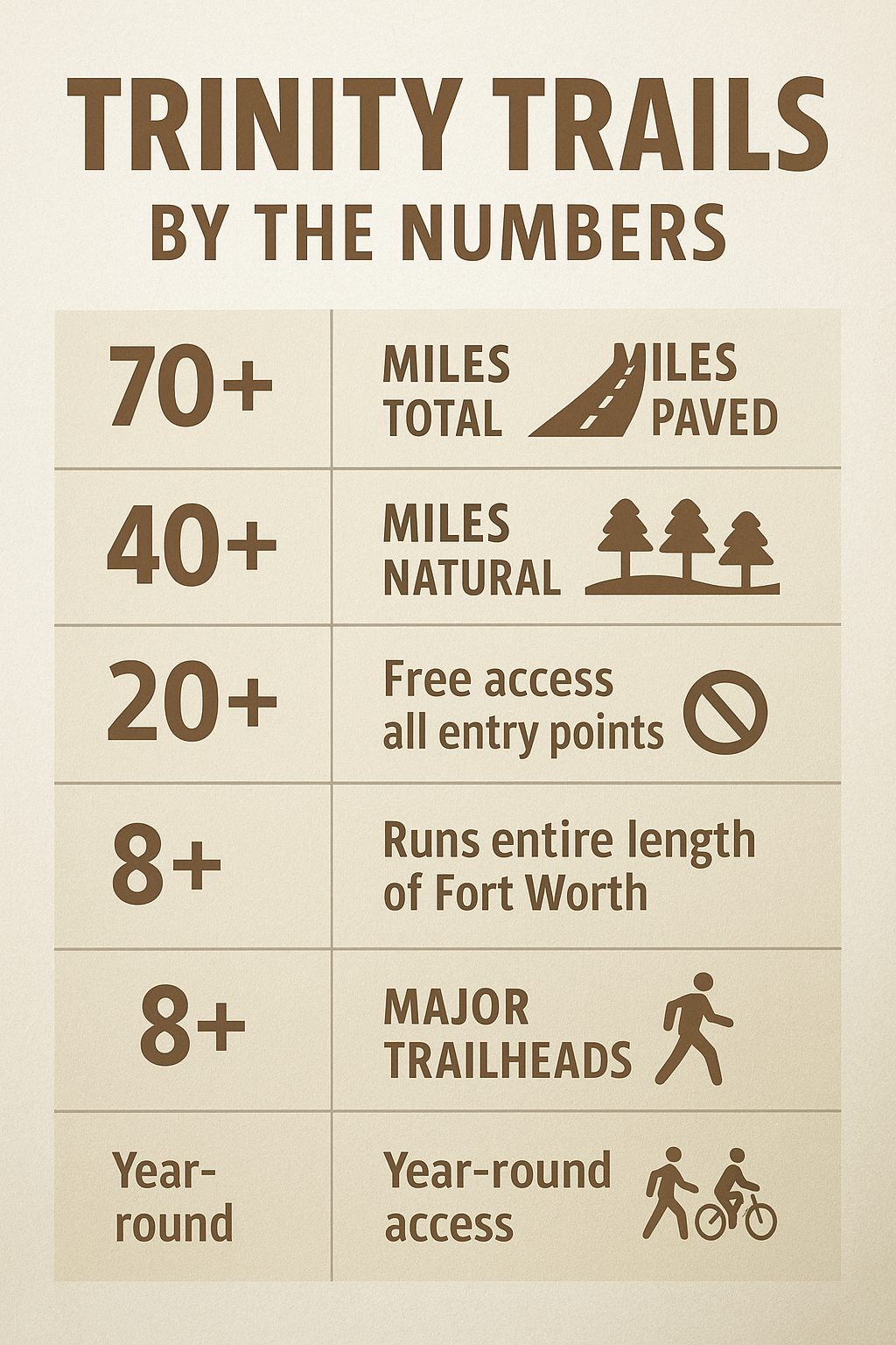
Planning your Trinity Trails adventure means accessing Fort Worth's crown jewel of urban outdoor recreation—a continuously expanding trail system that winds 70+ miles through the heart of the city along the Trinity River. Located everywhere and nowhere simultaneously, Trinity Trails connects neighborhoods, parks, and cultural attractions through paved pathways and natural surface trails that transform urban Fort Worth into a cyclist's and hiker's paradise.
Here's what makes Trinity Trails extraordinary: you're positioned on a comprehensive trail network that runs through the entire city offering free access and multiple entry points within minutes of virtually any Fort Worth neighborhood, connections between downtown attractions and natural areas along the Trinity River, paved trails perfect for cycling, running, and walking alongside natural surface options for hiking, and the unique ability to experience genuine nature corridors while never leaving the urban core. Whether you're commuting to work by bike, training for a marathon on safe car-free paths, exploring Fort Worth neighborhoods on two wheels, or taking an evening family walk along the river, this guide will help you navigate Trinity Trails strategically.
UNDERSTANDING TRINITY TRAILS: Fort Worth's Urban Greenway
Trail System Overview
What Trinity Trails Actually Is:
Trinity Trails isn't a single trail—it's an interconnected network of paved and natural surface trails following the Trinity River and its tributaries through Fort Worth. The system connects parks, neighborhoods, entertainment districts, and natural areas through dedicated pathways that keep users separated from vehicle traffic.
Three Distinct Trail Types:
Paved Multi-Use Trails (40+ miles):
Smooth concrete or asphalt surface
10-12 feet wide (two-way traffic)
Suitable for: Road bikes, hybrid bikes, inline skates, strollers, wheelchairs
Maintained year-round
Lighting in some urban sections
Most heavily used sections
Natural Surface Trails (20+ miles):
Dirt and gravel paths
Narrower (3-6 feet typical)
Suitable for: Mountain bikes, trail running, hiking
More challenging terrain (roots, rocks, elevation changes)
Less crowded than paved sections
Better wildlife viewing
Connector Routes (10+ miles):
Combination of trails, bike lanes, low-traffic streets
Link different trail sections
Urban infrastructure integration
Marked with signs and pavement markings
Geographic Reach:
Trinity Trails runs the entire north-south length of Fort Worth, roughly 25 miles from northern suburbs to southern city limits, following three primary corridors:
West Fork Trinity River: Main artery through west/central Fort Worth
Clear Fork Trinity River: Downtown and Cultural District connection
Village Creek: Eastern Fort Worth corridor
Why This System Works:
Unlike isolated park trails, Trinity Trails creates genuine transportation and recreation infrastructure. Commute to work, ride to dinner, explore neighborhoods, train for races, or walk the dog—all on car-free paths that make cycling and walking practical for daily life, not just weekend recreation.
History and Future Development
Development Timeline:
1970s: Initial trail concepts proposed
1990s: First trail segments constructed
2000s: Rapid expansion, major connections built
2010s: System reaches 60+ miles
2020s: Continued expansion toward 100-mile goal
Current Status (2024):
70+ miles operational
Additional segments under construction
Gap closure projects connecting isolated sections
Urban Loop vision advancing (23-mile downtown circuit)
Future Vision:
Fort Worth plans a 23-mile Urban Greenway Loop encircling the city's core, connecting transit stops, neighborhoods, schools, parks, and business districts. Currently about one-third complete, this loop will provide seamless car-free access across central Fort Worth.
Goals:
Greenway access within 1 mile of every community
100+ total miles by 2030
Complete Urban Loop closure
Enhanced connections to regional trails
Integration with public transportation
MAJOR TRAIL SEGMENTS
Trinity Park to Downtown (5 miles, Paved, Easy)
Segment Character:
Surface: Paved, excellent condition
Terrain: Mostly flat with gentle grades
Traffic: HIGH—most popular section
Scenery: Urban parks, river views, skyline
Best For: Casual rides, family outings, downtown access, running
Route Description:
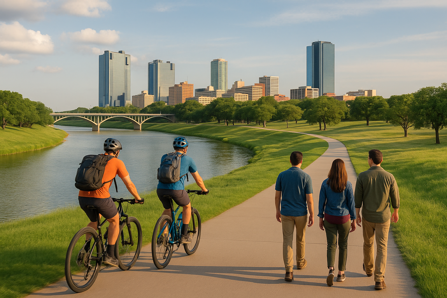
Starting from Trinity Park (near Cultural District), this segment follows the Trinity River eastward through some of Fort Worth's most scenic urban areas before arriving downtown. The trail passes through mature tree corridors, crosses under dramatic bridges, and offers constantly changing views of the city skyline.
Key Landmarks:
Trinity Park (Western terminus):
Large parking area
Restrooms and water fountains
Playground and picnic areas
Location: Near 7th Street and University Drive
Easy access toCultural District museums
University Drive Bridge:
Pass beneath historic bridge
Urban architecture framing river corridor
Graffiti art on bridge supports (changing)
7th Street Bridge:
Pedestrian/bike access via trail underpass
Views upriver and downriver
Photo opportunity (skyline perspective)
Downtown Arrival:
Trail delivers to downtown core
Connect toSundance Square
Access restaurants, entertainment, businesses
Multi-story parking for car + bike combinations
Why This Section Works:
Perfect introduction to Trinity Trails offering easy riding/walking with excellent amenities (water, restrooms, parking) at both ends. The section showcases Trinity Trails' purpose—connecting recreation with transportation while providing scenic, safe, car-free travel through the city.
User Mix:
Commuters (weekday mornings and evenings)
Recreational cyclists (weekends, all day)
Runners and walkers (constant)
Families (weekends especially)
Dog walkers (leashed dogs allowed)
Timing Strategy:
Early morning (6-8 AM): Fewer users, cooler temps, beautiful light
Midday (10 AM-2 PM): Busiest period, especially weekends
Evening (5-7 PM): Heavy commuter traffic weekdays, recreational users weekends
After 8 PM: Minimal traffic, some sections well-lit
Seasonal Highlights:
Spring: Trees leafing out, wildflowers in parks
Summer: Shaded sections comfortable early/late, avoid midday heat
Fall: Fall colors spectacular (cottonwoods, oaks), best overall season
Winter: Comfortable year-round use, fewer crowds
North Shore Section (8 miles, Paved, Easy-Moderate)
Segment Character:
Surface: Paved, good condition
Terrain: Gentle hills, some longer grades
Traffic: MODERATE—less crowded than Trinity Park section
Scenery: Most scenic urban views, multiple river crossings, natural areas
Best For: Longer rides/runs, photography, scenic cycling
Route Description:
The North Shore section runs through Fort Worth's northern neighborhoods, crossing the Trinity River multiple times via bridges that provide spectacular views. This segment offers the most dramatic scenery on Trinity Trails with sweeping river vistas, bridge crossings, and a perfect blend of nature and urban infrastructure.
Highlights:
Multiple Bridge Crossings:
Unique perspective from elevated bridges
Views up and down river corridors
Photo opportunities at each crossing
Connects both sides of river (route variety)
Gateway Park Connection:
Large park with extensive trail access
Multiple loops possible (extend or shorten ride)
Playground, splash pad (family destination)
Parking and facilities
Natural Areas:
Trail passes through wooded corridors
Wildlife viewing opportunities (herons, turtles, fish)
Feels removed from city despite urban location
Birding excellent (riparian habitat attracts diverse species)
Trail Features:
Slightly hillier than Trinity Park section (grade variety)
Some shade, some sun exposure (varied conditions)
Generally wider sections (less congestion)
Better maintained in recent years
Distance Options:
Short Loop (4-5 miles): Start Gateway Park, north to Marine Creek, return = ~5 miles
Medium Loop (8-10 miles): Gateway Park to Heritage Park and return = ~8 miles
Extended Ride (12-15 miles): Combine with Trinity Park section for longer continuous ride
Why Choose North Shore: Less crowded than central sections while offering superior scenery. Perfect for riders/runners wanting distance without dealing with heavy traffic on more popular segments.
Village Creek Trail (10 miles, Paved, Easy-Moderate)
Segment Character:
Surface: Paved, fair to good condition
Terrain: Gentle grades, mostly flat
Traffic: LOW to MODERATE—quieter section
Scenery: Natural corridors, suburban interface, Village Creek
Best For: Solitude, nature focus, connecting toRiver Legacy Park (Arlington)
Route Description:
Village Creek Trail follows its namesake creek through eastern Fort Worth and into Arlington's River Legacy Park system. This section offers the most nature-focused experience on Trinity Trails with extended natural corridors, abundant wildlife, and fewer urban intrusions.
Unique Features:
River Legacy Park Connection:
Trail continues into Arlington's extensive park system
1,300+ acres of bottomland forest
10 additional miles of trails (paved and natural surface)
Creates 20-mile continuous trail corridor
Arlington facilities available (restrooms, parking, water)
Wildlife Viewing:
Best wildlife section of Trinity Trails
White-tailed deer common (especially dawn/dusk)
Extensive bird diversity (forest and water birds)
Turtles, fish, occasional mammals
Quieter sections = more wildlife confidence
Natural Forest:
Mature bottomland forest corridors
Shade coverage excellent (summer advantage)
Fall colors spectacular (October-November)
Spring wildflowers and green-up
Lower Traffic: Eastern location and distance from downtown results in fewer users. Perfect for those seeking solitude and nature focus rather than urban energy.
Challenges:
Fewer facilities (restrooms, water) than western sections
More distance between major parking areas
Some sections need maintenance (variable condition)
Less familiar to many Fort Worth users (undiscovered gem)
Best Use: Long training rides (20+ miles Fort Worth to Arlington and return), nature-focused rides/runs, escaping crowds, serious workouts without interruption.
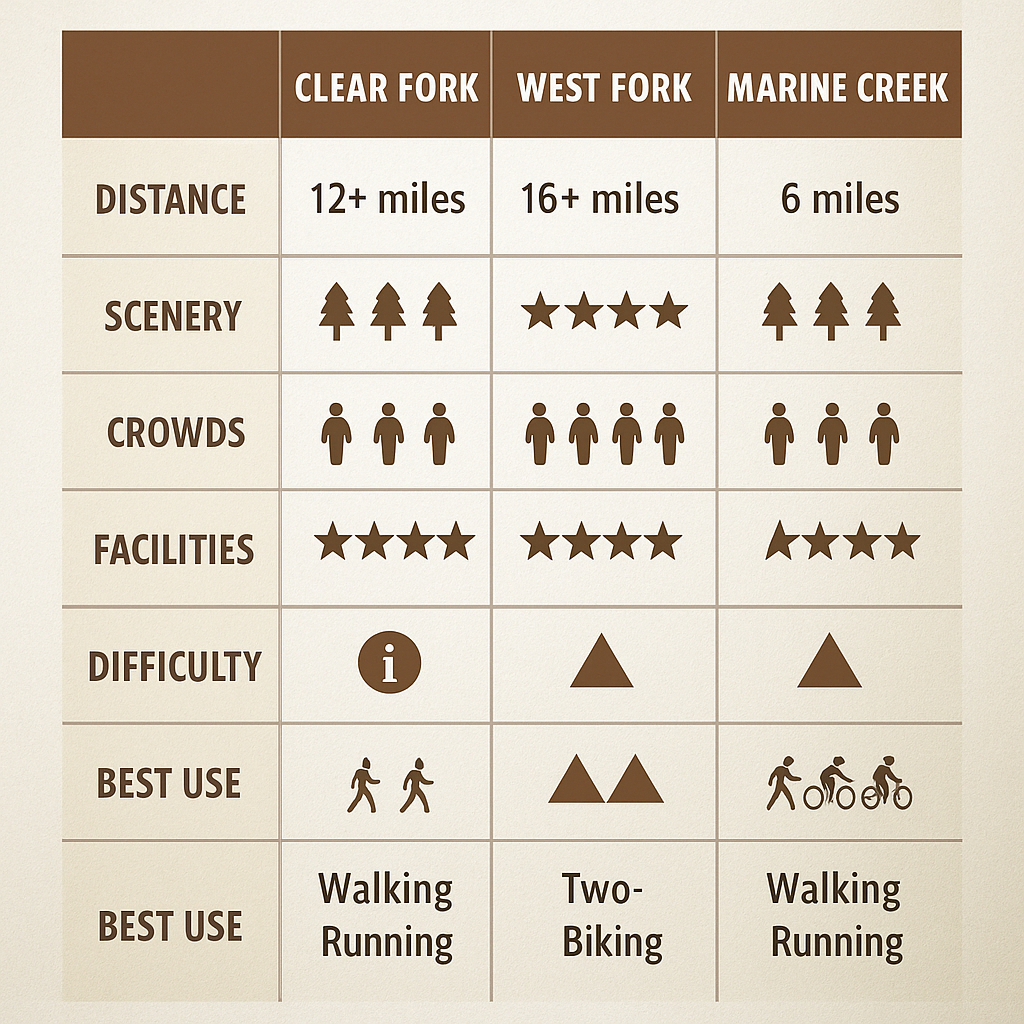
Clear Fork Section (6 miles, Paved, Easy)
Segment Character:
Surface: Paved, excellent condition
Terrain: Flat, urban corridor
Traffic: MODERATE to HIGH (weekends)
Scenery: Urban parks, Cultural District, downtown connection
Best For: Cultural District access, urban exploration, shorter rides
Route Description:
Clear Fork Trail follows the Clear Fork Trinity River through western Fort Worth, connecting the Cultural District, Trinity Park, and downtown. This section serves as primary access route for the city's museum district and western neighborhoods.
Cultural District Access:
Trail passes adjacent to museum
Bike racks available
Combine cycling with culture (ride to museum, explore, ride home)
Short ride from trail
World-class art collection
Bike parking available
Connected via trail system
Outdoor sculpture visible from trail
Restaurant accessible
Trail access nearby
Extensive gardens and natural areas
Bike parking at entrance
Trinity Park Hub: Clear Fork Section intersects Trinity Park, creating major trail junction where multiple routes converge. This hub provides:
Parking and facilities
Multiple route options (choose your adventure)
Playground and picnic areas
Natural starting point for rides
Urban Energy: More developed and urban than other sections with frequent park areas, neighborhood connections, and cultural institution access. Perfect for combining cycling with other activities—ride to museum, picnic in park, visit Botanic Garden, all in single outing.
NATURAL SURFACE TRAILS
Forest Park Trails (5 miles, Natural Surface, Moderate)
Trail Character:
Surface: Dirt, rocks, roots
Terrain: Rolling hills, technical sections
Traffic: LOW—mountain bikers and trail runners primarily
Scenery: Dense forest, challenging terrain
Best For: Mountain biking, trail running, skill development
Route Description:
Forest Park offers Trinity Trails' most challenging natural surface trails with technical terrain, elevation changes, and mountain bike-specific features. Located in northwest Fort Worth, these trails provide true singletrack experience within city limits.
Features:
Singletrack (narrow, one-person-wide trails)
Rock gardens (technical sections requiring skill)
Root sections (balance and bike handling)
Short climbs and descents (North Texas standards)
Switchbacks (tight turns on slopes)
Best For:
Mountain bikers seeking technical challenge
Trail runners wanting varied terrain
Skill development (technical riding practice)
Training for more challenging trails elsewhere
Difficulty: Moderate to challenging for mountain biking standards. Beginners should start on easier sections before attempting technical features.
Trail Maintenance: Maintained by volunteers and mountain bike community. Conditions vary with weather—best in dry conditions, can be muddy and challenging after rain.
River Legacy Trails (10 miles natural surface, Moderate)
Connected System:
While technically in Arlington, River Legacy Park's extensive natural surface trail network connects seamlessly with Trinity Trails Village Creek section, creating extended riding/running opportunities.
Trail Options:
Paved trails: 8 miles (family-friendly)
Natural surface: 10 miles (mountain bike, trail running)
Combination: Mix paved and natural for varied experience
Why Include River Legacy:
The connection makes River Legacy functionally part of Fort Worth's Trinity Trails system. Riders regularly combine Fort Worth and Arlington sections for 20-30 mile adventures mixing paved and natural surface.
Features:
Mature bottomland forest
Technical sections (roots, tight turns)
Beginner-friendly sections
Well-maintained and marked
Excellent facilities (restrooms, water, parking)
TRAILHEADS AND ACCESS POINTS
Major Trailheads with Facilities
Trinity Park (Primary Hub):
Location: 2401 University Drive, Fort Worth, TX 76107
Facilities: Large parking, restrooms, water fountains, playground, picnic areas
Trail Access: Trinity Park to Downtown section, Clear Fork section, multiple loop options
Best For: First-time users, families, group rides starting point
Nearby: Cultural District museums, Botanic Garden
Gateway Park:
Location: 2400 California Parkway, Fort Worth, TX 76107
Facilities: Parking, restrooms, water fountains, splash pad, playground
Trail Access: North Shore section, multiple loop configurations
Best For: North side access, scenic rides, family destination
Nearby: Residential neighborhoods, restaurants
Rockwood Park:
Location: 1851 Jacksboro Highway, Fort Worth, TX 76114
Facilities: Parking, restrooms, picnic areas
Trail Access: Northern trail sections
Best For: Northern Fort Worth residents, starting longer north rides
Nearby: Less developed areas, natural focus
Panther Island Pavilion:
Location: 395 Purcey Street, Fort Worth, TX 76102
Facilities: Parking (event-dependent), restrooms, water, event venue
Trail Access: Downtown connections, Clear Fork section
Best For: Downtown access, events, urban riding
Nearby: Downtown Fort Worth, restaurants, entertainment
Secondary Access Points (Limited/No Facilities)
Numerous Neighborhood Access Points:
Trinity Trails' design intentionally provides access points throughout Fort Worth neighborhoods, allowing residents to reach trails within 1-2 miles of most locations.
Typical Features:
Small parking areas (5-15 spaces)
Trail kiosk with map
No restrooms or water (bring your own)
Direct neighborhood connections
Finding Access Points:
Trinity Trails map: Available online atfortworthtexas.gov/trinitytrails
Google Maps: Search "Trinity Trails" shows access points
Trail signage: Directional signs throughout system
Local knowledge: Ask Fort Worth cyclists/runners
Strategy for Unknown Access: Start at major trailheads (Trinity Park, Gateway) for first visits. Once familiar with system, explore neighborhood access points closer to your location.
CYCLING THE TRINITY TRAILS
Road Cycling
Ideal Conditions: Trinity Trails' paved sections provide perfect road cycling environment:
Smooth pavement (road bike compatible)
Car-free (safety and speed)
Continuous distance (no stop signs, traffic lights on trail)
Training loops possible (repeat sections for mileage)
Popular Training Routes:
Short Loop (10-12 miles, 45-60 minutes): Trinity Park → Downtown → Return = ~10 miles Purpose: Quick workout, lunch-break ride, easy training
Medium Loop (20-25 miles, 1.5-2 hours): Gateway Park → Trinity Park → Downtown → Return = ~20 miles Purpose: Solid workout, endurance building, race training
Long Loop (30-40 miles, 2-3 hours): Rockwood Park → Gateway → Trinity Park → Downtown → Village Creek → Return Purpose: Serious training, century prep, full system exploration
Group Rides:
Fort Worth cycling community organizes regular group rides using Trinity Trails:
Weekday morning rides: 6-7 AM starts (before work)
Weekend group rides: Various skill levels and distances
Social rides: Evening casual pace rides
Training groups: Structured workouts for racing
Check:
Local bike shops (ride schedules posted)
Meetup.com cycling groups
Cycling clubs (Fort Worth Cycling Club, etc.)
Road Cycling Tips:
Pass Safely:
Announce passes: "On your left!" clearly
Wide berth (3+ feet) around walkers/runners
Slow for crowded sections
Courteous passing = shared trails working for everyone
Speed Management:
High speeds appropriate on empty sections
Slow for blind corners, bridges, congested areas
Weekends busier = slower speeds necessary
Early morning = faster riding possible (fewer users)
Equipment:
Road bike or hybrid
Helmet (mandatory for safety, smart for everyone)
Lights (front white, rear red—especially dawn/dusk)
Bell or voice (announce passes)
Water bottles (hydration critical, especially summer)
Mountain Biking
Natural Surface Sections:
Trinity Trails' natural surface options provide technical mountain biking within Fort Worth:
Forest Park trails (most technical)
River Legacy connection (varied terrain)
Scattered natural sections throughout system
Skill Levels:
Beginner:
Start on paved trails (build handling skills)
Progress to easy natural sections (River Legacy beginner trails)
Learn bike control before technical features
Intermediate:
Forest Park moderate sections
River Legacy technical trails
Handling roots, rocks, moderate climbs
Advanced:
Forest Park technical features
High-speed natural surface riding
Jump features and rock gardens (where present)
Mountain Bike Etiquette:
Yield to hikers (always)
Announce passes
Control speed (safe for conditions and other users)
No skidding (trail damage)
Respect wet closures (protect trail integrity)
Bike Type:
Hardtail mountain bike (sufficient for most Trinity Trails terrain)
Full suspension (more comfortable but unnecessary)
NOT road bikes (natural surface requires mountain bike)
Commuting by Bike
Trinity Trails as Transportation:
One of Trinity Trails' primary purposes is enabling bicycle commuting. Thousands of Fort Worth residents use the trail system for car-free commutes to work, school, and daily destinations.
Commuting Advantages:
Car-free: Safe, no traffic interaction
Scenic: Better than highway commute
Exercise: Built into daily routine (no extra time for gym)
Cost savings: No gas, parking fees, vehicle wear
Reliable: No traffic delays, predictable timing
Popular Commute Routes:
Neighborhoods → Downtown: Western and northern neighborhoods connected directly to downtown via Trinity Trails. Many professionals ride to downtown offices using trail system exclusively.
Cultural District → Downtown: Museum employees, university staff, and residents commute between these areas using Trinity Park to Downtown section.
Cross-City Commutes: Some adventurous commuters ride 10-15 miles each direction, using Trinity Trails for safe, pleasant daily transportation.
Commuting Tips:
Equipment:
Hybrid or commuter bike (comfortable, durable)
Panniers or backpack (carry work clothes, laptop)
Lights (essential for dawn/dusk riding)
Fenders (wet weather protection)
Lock (secure at destination)
Clothing Strategy:
Ride in athletic clothes
Change at work (most offices accommodate bike commuters)
OR ride in work clothes at moderate pace
Keep change of clothes at office (weather backup)
Year-Round Commuting:
Summer: Early start (6-7 AM), shower at work, afternoon challenge (heat)
Winter: Layer appropriately, enjoyable temps (40s-60s°F typical)
Rain: Fenders and rain jacket, or drive those days
Safety: Lights always, high-visibility clothing, especially winter (shorter daylight)
RUNNING AND WALKING
Running the Trinity Trails
Runner's Paradise:
Trinity Trails serves Fort Worth's running community with car-free paths, measured distances, varied terrain, and endless route configurations.
Training Routes:
Short Runs (3-5 miles):
Trinity Park loops
Downtown out-and-back
Neighborhood access points to trail and return
Medium Runs (6-10 miles):
Trinity Park to Downtown and return (~10 miles)
Gateway Park loops (various configurations)
Clear Fork explorations
Long Runs (12-20+ miles):
Full system traverses (north to south)
Multiple loop combinations
Marathon training distances easily achievable
Run Training Benefits:
Measured Distances:
Trail markers indicate mileage
GPS tracking easy (consistent path)
Repeat routes = progress tracking
Safety:
No traffic (car-free)
Well-used (safety in numbers)
Emergency access (roads cross frequently)
Surfaces:
Paved (easy on joints, consistent pace)
Natural surface (trail running, varied terrain)
Choose based on training goals
Running Groups:
Fort Worth running community embraces Trinity Trails:
Store-sponsored runs (Luke's Locker,Fleet Feet)
Social running groups
Marathon training groups (Trinity Trails = primary training ground)
Runner Etiquette:
Stay right (allow faster users to pass left)
Don't block trail (groups single file on crowded sections)
Headphones awareness (keep volume low enough to hear passes, bikes)
Early morning = fewer conflicts with cyclists
Walking and Family Use
Family-Friendly Features:
Trinity Trails serves Fort Worth families with safe, accessible outdoor recreation:
Stroller-friendly (paved, smooth surface)
Playground connections (Gateway, Trinity Park)
Restroom access (major trailheads)
Shaded sections (summer comfort)
Multiple distance options (short walks to extended hikes)
Popular Family Routes:
Trinity Park Loop (2-3 miles):
Start/end at Trinity Park parking
Playground and picnic areas
Restrooms and water
Short, achievable for young children
Gateway Park to Heritage (3-4 miles):
Playground at Gateway
Scenic river views
Moderate distance
Return to facilities at Gateway
Short Out-and-Back Walks:
Neighborhood access → 1 mile out → return = 2 miles total
Customize distance to family ability
Turn around when ready (flexible)
Family Tips:
With Young Children:
Start short (1-2 miles maximum)
Bring snacks and water
Plan around nap times
Have destination (playground, specific landmark)
Make it fun (count bridges, spot wildlife, treasure hunts)
With Strollers:
All paved sections stroller-accessible
Jogging strollers ideal (larger wheels, suspension)
Avoid natural surface sections (too rough)
Safety:
Children stay to right side of trail
Teach trail etiquette early (listen for "on your left")
Bright clothing (visibility)
Supervise closely near water
Dog Walking:
Trinity Trails allows leashed dogs (6-foot leash maximum):
Popular dog-walking destination (hundreds daily)
Waste bag stations at major trailheads (bring bags)
Dogs must be under control (no aggression toward other dogs/people)
Summer caution: Hot pavement burns paws (early morning, evening walks only)
Water for dogs (no natural water sources safe for drinking)