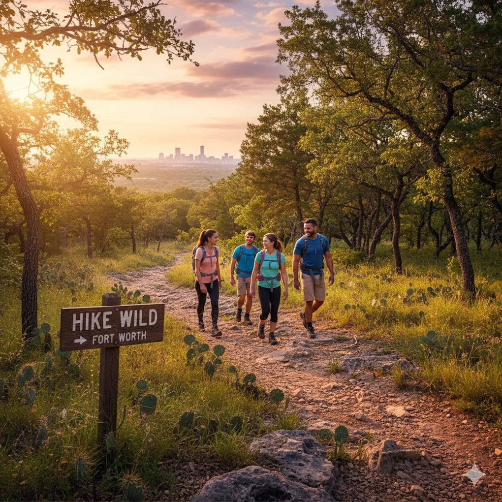
Hike Wild Fort Worth: Nature, Trails & Wildlife Bliss
Planning your hiking adventure at the Fort Worth Nature Center & Refuge means accessing one of the largest city-owned nature centers in the United States. Located just 15 minutes northwest of downtown Fort Worth, this 3,621-acre urban wilderness offers 20+ miles of trails ranging from easy nature walks to challenging backcountry treks, all while providing encounters with bison herds, diverse bird species, and pristine ecosystems that feel worlds away from the city.

Here's what makes the Nature Center extraordinary: you're positioned in a genuine wilderness preserve within Fort Worth city limits offering diverse ecosystems from prairie to bottomland forest, a resident bison herd you can view from hiking trails, over 20 miles of well-maintained trails for all skill levels, the only overnight backpacking opportunity within Fort Worth, and educational programs that deepen your connection to North Texas ecology. Whether you're seeking an easy family nature walk on paved paths, a challenging day hike through rugged terrain, or even an overnight backpacking adventure without leaving the city, this guide will help you navigate the Nature Center strategically.
UNDERSTANDING THE NATURE CENTER: What Makes It Special
Location and Overview
The Basics:
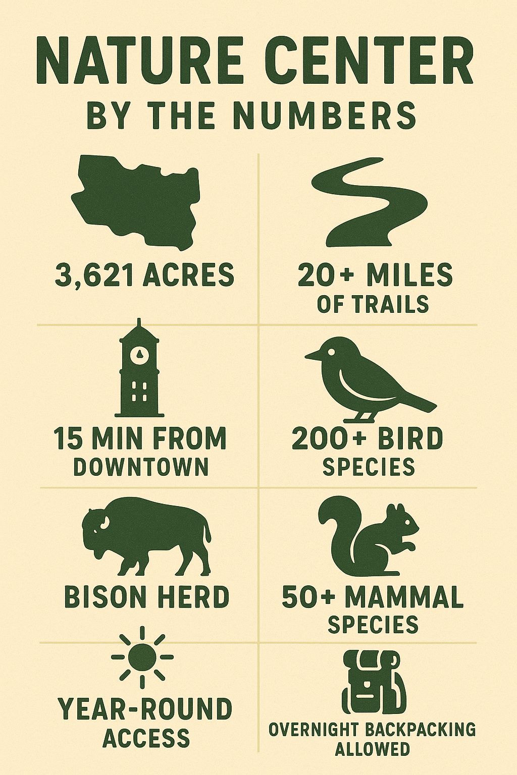
Size: 3,621 acres (one of largest city-owned nature centers in US)
Location: 9601 Fossil Ridge Road, Fort Worth, TX 76135
Distance: 15 minutes northwest of downtown Fort Worth
Established: 1964 as wildlife refuge
Managing Agency: Fort Worth Parks & Recreation
Admission: $7 adults, $3 children (4-12), under 4 free
Hours: 8:00 AM - 5:00 PM daily (extended summer hours)
Annual Pass: Available for frequent visitors
What Makes It Unique:
The Fort Worth Nature Center isn't a typical urban park with manicured lawns and playgrounds—it's a genuine wildlife refuge dedicated to preserving native North Texas ecosystems. The preserve protects bottomland hardwood forest, native prairie, and riparian habitat along the Trinity River, creating a living laboratory for native plants and animals.
Unlike distant state or national parks requiring full-day commitments, the Nature Center delivers wilderness hiking experiences within 15 minutes of urban Fort Worth. Launch a morning hike, explore 5-8 miles of backcountry trails, encounter bison and wildlife, and still make lunch plans in the city.
Geographic Position:
On peninsula formed by Lake Worth and West Fork Trinity River
Surrounded by water on three sides (creates island-like isolation)
Elevation changes from 550 feet (bottomland) to 700 feet (ridge tops)
150 feet of relief (significant for North Texas)
Located on Eastern Cross Timbers ecological transition zone
Ecosystems and Habitats
Five Distinct Ecosystems:
Prairie Grasslands:
Native tallgrass prairie restoration
Dominated by big bluestem, little bluestem, Indiangrass
Wildflowers peak April-May and September-October
Bison herd grazes and maintains prairie
Open views, full sun exposure
Bottomland Hardwood Forest:
Floodplain forest along Trinity River
Mature trees: American elm, cottonwood, sycamore, ash
Cool, shaded hiking in summer
Rich wildlife habitat (birds, mammals, reptiles)
Trails wind through dense canopy
Eastern Cross Timbers:
Post oak and blackjack oak savanna
Characteristic North Texas ecosystem
Transition between eastern forests and western prairies
Rocky outcrops and moderate slopes
Beautiful fall colors
Riparian Corridors:
Streamside habitats along creeks
Dense vegetation, water-loving plants
Critical wildlife corridors
Boardwalks protect sensitive areas
Freshwater Marsh:
Wetland habitats with standing water
Cattails, sedges, aquatic plants
Exceptional bird watching (waterfowl, wading birds)
Boardwalk and observation platforms
Why Ecosystem Diversity Matters: The variety of habitats concentrates wildlife and provides different hiking experiences within single visits. Hike through cool bottomland forest, emerge onto sunny prairie, climb rocky ridges, and explore marsh boardwalks—all in one 4-6 mile loop.
TRAIL SYSTEM OVERVIEW
Trail Network and Difficulty
20+ Miles Total Trails:
Paved/Accessible: 1.5 miles (wheelchair accessible)
Easy Natural Surface: 3-4 miles (family-friendly)
Moderate Trails: 8-10 miles (some elevation, longer)
Challenging/Backcountry: 6-8 miles (rugged, remote)
Backpacking Trail: 10 miles (overnight camping allowed)
Trail Markings:
Color-coded trail markers (follow blazes on trees)
Junction signs at major intersections
Trail maps at kiosks (Visitor Center, trailheads)
Download map fromfwnaturecenter.org before visit
Trail Conditions:
Well-maintained by staff and volunteers
Natural surface (dirt, rocks, roots)
Some sections muddy after rain
Rocky areas require sturdy footwear
Elevation changes (stairs, steep sections on some trails)
Trail Etiquette and Rules
Critical Rules:
Stay on marked trails (protect sensitive habitats)
No pets allowed (wildlife protection—service animals only)
No bicycles on trails (hiking only)
Pack out all trash (Leave No Trace)
No collecting plants, rocks, or artifacts
Hunting prohibited (wildlife refuge)
Fishing allowed with Texas license (designated areas)
Etiquette:
Yield to uphill hikers
Step aside for faster hikers
Keep noise down (wildlife viewing, others' experience)
Don't feed wildlife (dangerous, illegal)
Close gates behind you (livestock management)
Safety:
Tell someone your hiking plan
Carry water (Texas heat, no water on trails)
Watch for snakes (copperheads, rattlesnakes—not aggressive but present)
Tick checks after hiking (ticks common March-October)
Stay on trails (easy to get disoriented in dense forest)
EASY TRAILS: Family-Friendly Hiking
Hardwicke Interpretive Trail (0.8 miles, 30-45 minutes, Easy)
Trail Character:
Surface: Paved, fully accessible
Elevation: Flat, minimal elevation change
Difficulty: Easy (wheelchair accessible, stroller-friendly)
Highlights: Interpretive signs, boardwalk, marsh viewing
Best For: Families with young children, wheelchair users, nature education
Route Description: Starting from the Visitor Center, this paved trail loops through bottomland forest and along marsh edges. Interpretive signs explain North Texas ecology, native plants, and wildlife. Boardwalk sections cross wetland areas where turtles, frogs, and wading birds are common.
Why This Trail Works: Perfect introduction to the Nature Center for first-time visitors or families with small children. The paved surface and short distance make it accessible to everyone, while interpretive signs provide educational value beyond just hiking.
Wildlife Viewing:
Turtles: Sunning on logs in marsh (spring-fall)
Great blue herons: Fishing along water edges
Frogs: Listen for calls spring-summer
Butterflies: Abundant around native plants (April-October)
Songbirds: Dense vegetation attracts diverse species
Pro Tips:
Start at Visitor Center (bathrooms, water, maps)
Morning or late afternoon best for wildlife activity
Bring binoculars (wildlife viewing from boardwalk)
Allow time to read interpretive signs (educational value)
Caprock Nature Trail (2 miles loop, 1-1.5 hours, Easy-Moderate)
Trail Character:
Surface: Natural surface (dirt, some rocks)
Elevation: Gentle slopes, ~50 feet gain
Difficulty: Easy-Moderate (some uneven terrain)
Highlights: Prairie views, rock outcrops, panoramic vistas
Best For: Families with older children, beginner hikers, scenic short hike
Route Description: Loop trail that climbs gently from bottomland to caprock outcrops on ridge top. Trail passes through mixed forest before emerging onto prairie overlook with views across Lake Worth and Nature Center. Descend through oak woodland back to trailhead.
Key Features:
Rock outcrop viewpoint (best vista on easy trails)
Prairie ecosystem exposure
Moderate distance (substantial without overwhelming)
Well-marked junctions
Seasonal Highlights:
Spring (March-May): Wildflowers on prairie, migrating birds
Summer (June-August): Shade in forest sections, morning only recommended
Fall (September-November): Fall colors, comfortable temps, best season
Winter (December-February): Clear views, fewer hikers, crisp air
Wildlife:
White-tailed deer (common, especially dawn/dusk)
Armadillos (often seen rooting in leaf litter)
Hawks and vultures (soaring above prairie)
Lizards on rock outcrops (spring-fall)
Best Strategy: Hike counterclockwise (gradual climb, steeper descent feels easier than reverse). Start early morning for wildlife viewing and cooler temps. Bring water—no water sources on trail.
Cottonwood Trail (1.5 miles, 45 minutes - 1 hour, Easy)
Trail Character:
Surface: Natural surface, mostly flat
Elevation: Minimal (bottomland forest)
Difficulty: Easy (slight uneven terrain only challenge)
Highlights: Huge cottonwood trees, shaded forest, creek crossing
Best For: Summer hiking (maximum shade), tree enthusiasts, easy nature walk
Route Description: Flat trail through mature bottomland forest along small creek. Pass beneath massive cottonwood, elm, and sycamore trees creating dense canopy. Boardwalk crosses wettest section. Peaceful, quiet trail with excellent bird watching.
Why Choose Cottonwood:
Shade: 90%+ canopy coverage (summer heat management)
Accessibility: Nearly flat (easy for all ages)
Quiet: Less trafficked than other trails
Big trees: Some of Nature Center's largest specimens
Bird watching: Dense forest attracts diverse bird species
Seasonal Considerations:
Spring: May be muddy after rains (wear appropriate footwear)
Summer: Coolest hiking option (shade, breeze through canopy)
Fall: Cottonwood leaves turn golden yellow
Winter: Bare trees reveal forest structure, easier wildlife spotting
MODERATE TRAILS: Challenging Day Hikes
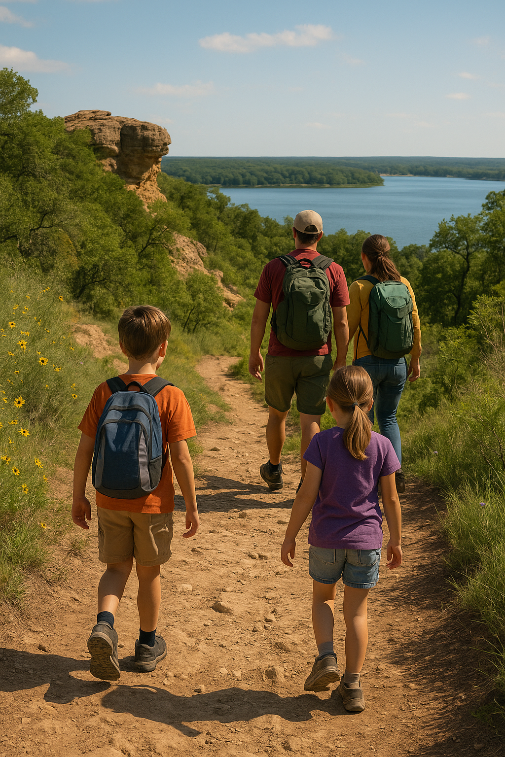
Canyon Ridge Trail (4 miles loop, 2-3 hours, Moderate)
Trail Character:
Surface: Natural surface, rocky sections
Elevation: ~150 feet gain (significant for North Texas)
Difficulty: Moderate (elevation changes, some technical sections)
Highlights: Best views in Nature Center, Trinity River overlooks, diverse habitats
Best For: Fit hikers wanting substantial workout, photographers, experienced hikers
Route Description: The Nature Center's premier trail climbs from bottomland forest to ridge top with spectacular Trinity River and Lake Worth views. Route passes through all major ecosystems—bottomland forest, oak savanna, prairie, and rocky outcrops. Some steep sections require careful footing.
Why Canyon Ridge Is Special: Most dramatic topography and best panoramic views in the Nature Center. Trail rewards elevation gain with overlooks spanning miles across Trinity River valley. Varied ecosystems mean diverse wildlife and constantly changing scenery.
Key Sections:
Bottomland Start:
Cool, shaded forest along creek
Large trees create cathedral-like atmosphere
Gentle warmup before climb begins
Ridge Climb:
Steepest section (200-300 yards)
Rocky footing requires attention
Gain ~100 feet elevation quickly
Ridge Top:
BEST VIEWS: Panoramas across Trinity River
Rock outcrops for rest stops and photos
Prairie openings with wildflowers (season dependent)
Exposure to sun and wind
Descent:
Gradual decline through oak forest
Return to bottomland forest
Complete ecosystem tour
Wildlife Potential:
Highest elevation = raptor viewing (hawks, vultures soaring)
Deer common on ridge (browse oak forest)
Prairie birds (meadowlarks, sparrows)
Bottomland birds (woodpeckers, warblers)
Timing Strategy:
Best season: Fall (September-November) and spring (March-May)
Best time: Morning (7-10 AM) for wildlife, cooler temps, better light
Avoid: Summer midday (exposed ridge, 95-105°F)
Allow: 2-3 hours with photo stops, wildlife viewing
Required Gear:
Sturdy hiking boots (rocky, uneven terrain)
1-2 liters water per person (no water on trail)
Snacks
Hat and sunscreen (exposed ridge section)
Camera (exceptional photo opportunities)
Cottonwood-Shoreline Combination (5 miles, 2.5-3.5 hours, Moderate)
Route Description: Combine Cottonwood Trail with Shoreline Trail for extended bottomland forest hiking along Lake Worth shore. This combination provides longest continuous shaded hiking in Nature Center.
Trail Character:
Mostly flat (bottomland forest)
Longer distance provides challenge without steep climbing
Maximum shade (summer option for longer hike)
Lake Worth views from Shoreline Trail
Less crowded than shorter trails
Best For:
Distance training without extreme elevation
Summer hiking (shade, breeze from lake)
Bird watching (forest and water interface)
Meditative, peaceful hiking
Highlights:
Lake Worth shoreline access
Massive trees in mature bottomland forest
Wildlife corridors (mammals, birds)
Quiet, remote feeling despite proximity to city
Refuge Trail System (6-8 miles, 3-4 hours, Moderate-Challenging)
Route Description: Link multiple trails—Caprock, Cottonwood, Shoreline, Canyon Ridge—for extended hiking that samples all Nature Center ecosystems. Create custom routes based on distance goals and time available.
Strategy:
Start Visitor Center (water, bathrooms, maps)
Head to bottomland trails (Cottonwood, Shoreline)
Climb to ridge trails (Caprock, Canyon Ridge)
Descend back to start
Total distance 6-8 miles depending on specific route
Why Link Trails:
Experience full diversity of Nature Center
Extended workout without repeating trails
See multiple ecosystems in single hike
Wildlife variety (different habitats = different species)
CHALLENGING TRAILS: Backcountry and Backpacking
Backcountry Trail System (10+ miles, 5-7 hours, Challenging)
Trail Character:
Surface: Rugged natural surface, minimal maintenance
Elevation: Multiple climbs and descents
Difficulty: Challenging (distance, elevation, navigation)
Highlights: Remote wilderness feeling, solitude, diverse ecosystems
Best For: Experienced hikers, backpackers, those seeking challenge
What Makes It Backcountry: These trails venture into the Nature Center's most remote sections where you may hike hours without seeing other people. Trail markings exist but require attention to follow. Terrain is more rugged with less maintenance than front-country trails.
Backcountry Skills Required:
Navigation (map reading, staying on trail)
Self-sufficiency (carry all water, food, first aid)
Fitness (10+ miles in 5-7 hours)
Proper gear (sturdy boots, backpack, layers)
Risk assessment (weather, wildlife, injury)
Overnight Backpacking (10 mile loop, Permit Required)
Unique Opportunity: The Fort Worth Nature Center offers the only overnight backpacking experience within Fort Worth city limits. Designated backcountry campsites allow hikers to experience wilderness camping without traveling to distant state parks.
How It Works:
Permits Required:
Reserve backcountry campsite in advance
Contact Nature Center office: (817) 392-7410
Permit fee: ~$10-15 per person (check current rates)
Limited capacity (protects wilderness experience)
Book weeks ahead for popular dates
Designated Campsites:
Primitive sites (no facilities)
Fire rings provided
Must pack out all trash
No water at campsites (carry all water)
Tent camping only
Route Planning:
10-mile loop connects campsites
Hike in 4-5 miles to campsite (afternoon)
Set up camp, explore area
Morning wildlife viewing
Hike out 5-6 miles (morning)
Total: ~10 miles over two days
Required Gear:
Backpacking tent
Sleeping bag and pad
Backpacking stove (fires allowed but variable restrictions)
Food for 2 days
Water: 3-4 liters (heavy but necessary—no sources)
First aid kit
Navigation tools (map, compass, GPS)
Headlamp
Bear bag or hang system (raccoons, not bears)
Best For:
Backpackers wanting overnight experience near home
Testing gear before longer trips
Introducing family/friends to backpacking
Experiencing Nature Center at night (sounds, stars, nocturnal wildlife)
Seasonal Considerations:
Best Seasons:
Fall (October-November): Ideal temps, comfortable nights, beautiful colors
Spring (March-April): Good temps, wildflowers, migrating birds
Avoid Summer: Extreme heat, humidity, limited water sources dangerous
Winter Backpacking:
Possible but cold nights (20s-30s°F)
Less crowded (solitude)
Requires cold weather gear
Beautiful but challenging
WILDLIFE VIEWING GUIDE
The Bison Herd
Fort Worth's Urban Buffalo: The Nature Center maintains a bison herd that grazes native prairie, serving both as wildlife attraction and ecological management tool. Bison grazing maintains prairie health by preventing woody plant encroachment.
Herd Details:
~30 animals (herd size varies)
American bison (not buffalo—bison is correct term)
Free-roaming within designated prairie area
Visible from Prairie Trail and viewing areas
Viewing Strategy:
Best Times:
Early morning (6-9 AM): Active grazing, cooler temps
Late afternoon (4-6 PM): Evening feeding, golden light
Avoid midday: Bison rest in shade during heat
Best Locations:
Prairie Trail overlook (elevated viewing)
Viewing platforms (staffed can provide information)
Binoculars recommended (safe distance viewing)
Safety Rules:
NEVER approach bison (wild animals, dangerous)
Minimum 100 yards distance (seriously—they can charge)
Stay on trails (do not enter prairie)
No feeding (illegal, dangerous)
Respect barriers and signs
Bison Behavior:
Generally peaceful if left alone
Can run 35+ mph (much faster than humans)
Will charge if threatened or approached
Bulls aggressive during rut (July-August)
Cows protective of calves (spring)
Photography Tips:
Telephoto lens (200mm+) for safety and quality
Early/late light for best photos
Dust during running creates dramatic images
Patient observation rewarded
Bird Watching (200+ Species)
Why Nature Center Excels: Diverse habitats concentrated in 3,621 acres create exceptional birding. The Nature Center's location on Central Flyway migration route adds seasonal variety to resident species.
Resident Species (Year-round):
Woodpeckers (pileated, red-bellied, downy)
Carolina chickadees
Tufted titmice
Cardinals
Blue jays
Hawks (red-tailed, Cooper's)
Great blue herons
Various ducks and geese
Migratory Species:
Spring (March-May):
Warblers (20+ species)
Vireos
Tanagers
Orioles
Buntings
Peak: Late April-early May
Fall (September-November):
Return migration (same species different timing)
Raptors (hawks migrating south)
Waterfowl arriving for winter
Peak: October
Winter Visitors (November-February):
Ducks and geese (wintering waterfowl)
Sparrows
Juncos
Ruby-crowned kinglets
Best Birding Trails:
Cottonwood Trail: Forest birds, woodpeckers
Marsh boardwalk: Waterfowl, herons, rails
Prairie edges: Grassland birds, raptors
Shoreline Trail: Water birds, forest-water interface
Birding Strategy:
Early morning best (peak activity, birds singing)
Bring binoculars (essential for identification)
Field guide or birding app (eBird, Merlin)
Move slowly and quietly
Listen (many birds heard before seen)
Weekdays less crowded (better birding)
Mammals and Reptiles
Common Mammals:
White-tailed deer: Most common large mammal, dawn/dusk
Raccoons: Nocturnal but occasionally seen
Armadillos: Often seen rooting in leaf litter
Rabbits: Cottontails in prairie and edges
Squirrels: Fox squirrels and gray squirrels
Coyotes: Present but rarely seen (hear howling occasionally)
Bobcats: Rare sightings (secretive, mostly nocturnal)
Reptiles (March-October):
Turtles: Red-eared sliders, box turtles
Lizards: Fence lizards, anoles on tree trunks
Snakes: Non-venomous (rat snakes, water snakes, garter snakes)
Venomous snakes: Copperheads (rocky areas), rattlesnakes (rare)
Snake Safety:
Watch where you step (rocks, logs, leaf litter)
Stay on trails (avoid tall grass)
Don't reach into crevices or under rocks
Give snakes space (they want to avoid you)
Copperheads well-camouflaged (watch carefully)
Bites rare (snakes not aggressive, defensive only)
If bitten: Stay calm, immobilize limb, seek immediate medical care
SEASONAL HIKING GUIDE
Spring (March-May)
Conditions:
Temps: 60s-80s°F (comfortable)
Rainfall: Moderate (trails may be muddy)
Wildflowers: Peak bloom April-May
Birds: Spring migration spectacular
Crowds: Moderate, increasing toward summer
Why Spring Excels:
Wildflowers: Native prairie and forest wildflowers peak
Migration: 100+ migrating bird species pass through
Comfortable temps: Ideal hiking weather before summer heat
Green-up: Trees leafing out, landscape transforming
Wildlife active: Breeding season, animals visible
Spring Challenges:
Muddy trails after rain (especially bottomland)
Ticks emerge (peak April-June)
Occasional thunderstorms (monitor weather)
Poison ivy leafing out (stay on trails)
Best Spring Hikes:
Prairie trails for wildflowers (Caprock, Prairie Trail)
Marsh boardwalk for migrating waterfowl
Canyon Ridge for panoramic spring views
Early morning for bird migration waves
What to Bring:
Tick repellent and do tick checks after hiking
Rain jacket (spring storms)
Camera (wildflowers, birds)
Field guides (flower identification)
Summer (June-August)
Conditions:
Temps: 90-105°F (extreme heat!)
Humidity: High (heat index 100-110°F+)
Rainfall: Variable (drought possible, occasional storms)
Wildlife: Less visible (midday heat)
Crowds: Lower (heat deters casual hikers)
Summer Survival:
Timing Critical:
Early morning only: 6:30-10:00 AM (before peak heat)
Evening option: 6:00-8:00 PM (post-heat, sunset hikes)
Avoid midday: 11 AM-5 PM dangerous heat
Trail Selection:
Bottomland forest trails: Maximum shade (Cottonwood, Shoreline)
Avoid exposed trails: Prairie and ridge trails unshaded, extreme heat
Short distances: Heat reduces safe hiking distance
Hydration Essential:
1 liter water per hour hiking minimum
Electrolyte drinks (sweat loss significant)
Drink before thirsty (dehydration prevention)
Carry more than you think needed
Heat Safety:
Heat exhaustion symptoms: Dizziness, nausea, heavy sweating, weakness
Heat stroke: Confusion, no sweating, hot dry skin—MEDICAL EMERGENCY
Prevention: Early hiking, hydration, shade, rest breaks
Turn back if feeling unwell
Summer Advantages:
Solitude (fewer hikers)
Shaded trails comfortable early morning
Wildlife concentrated near water sources
Extended daylight (longer hiking windows if cool)
Fall (September-November)
Conditions:
Temps: 80s-60s°F (gradually cooling, comfortable)
Humidity: Lower (comfortable)
Rainfall: Less than spring (stable weather)
Fall colors: Peak late October-early November
Crowds: Moderate (locals' favorite season)
Why Fall is Best:
Perfect temperatures: Comfortable all-day hiking
Fall colors: Oak, elm, cottonwood turning
Migration: Fall bird migration (raptors especially)
Stable weather: Fewer thunderstorms than spring/summer
All trails accessible: No heat limitations
Fall Highlights:
October:
Peak fall color (late month)
Comfortable temps (70s-80s°F)
Monarch butterfly migration
Best month overall
November:
Cooling temps (60s-70s°F)
Clearer air (lower humidity)
Fewer crowds post-October
Waterfowl arriving for winter
Best Fall Hikes:
Canyon Ridge for panoramic fall color views
All trails excellent (no heat restrictions)
Longer distances comfortable (8-10 mile days)
Photography expeditions (golden light, fall colors)
Fall Strategy: Mid-morning starts (8-10 AM) provide ideal conditions without early wake-up. Fall allows leisurely hiking without summer's time pressure or spring's mud concerns.
Winter (December-February)
Conditions:
Temps: 40s-60s°F (variable)
Occasional freezes (20s-30s°F some mornings)
Lower rainfall (drier trails)
Bare trees (better views, wildlife spotting)
Minimal crowds (nearly empty weekdays)
Why Winter Works:
Solitude: Fewest visitors (have trails to yourself)
Views: Bare trees reveal vistas blocked by summer foliage
Wildlife spotting: Easier to see without leaf cover
Comfortable: Midday temps often 50s-60s°F
No bugs: Ticks, mosquitoes, chiggers absent
Winter Considerations:
Dress in layers: Morning cold (30s-40s), midday warm (50s-60s)
Ice possible: Trails icy after winter storms (rare but possible)
Shorter days: Less daylight for extended hikes
Cold water: Hypothermia risk if crossing wet areas
Best Winter Hikes:
Midday hiking (11 AM-3 PM warmest)
All trails accessible (no heat/mud limitations)
Ridge trails offer views without summer leaf obstruction
Photography (bare trees, winter light, occasional snow)
Winter Wildlife:
Wintering waterfowl (ducks, geese on Lake Worth)
Resident birds more visible (no leaf cover)
Deer more visible in leafless forest
Tracks in mud/rare snow
WHAT TO BRING
Essential Gear (Every Hike)
Hydration:
Water: 1 liter per 2 hours minimum (more in summer)
Extra water (no sources on trails)
Electrolyte drinks (summer especially)
Footwear:
Hiking boots or sturdy trail shoes (ankle support recommended)
NOT sandals, flip-flops, or casual shoes
Broken-in footwear (blisters ruin hikes)
Sun Protection:
Sunscreen SPF 30+ (reapply)
Hat with brim
Sunglasses
Long-sleeve shirt (lightweight, breathable)
Navigation:
Trail map (get at Visitor Center or download)
Phone (limited cell service but some coverage)
Watch (track time, turnaround planning)
Safety:
First aid kit (basic: bandages, pain reliever, blister treatment)
Whistle (signal for help)
Phone (emergency calls)
Comfort:
Daypack (carry water, layers, snacks)
Snacks (trail mix, energy bars, fruit)
Layers (remove/add as temps change)
Season-Specific Additions
Spring:
Tick repellent
Rain jacket
Camera (wildflowers)
Binoculars (bird migration)
Summer:
Extra water (2-3 liters)
Lightweight, breathable clothing
Cooling towel
Electrolyte supplements
Fall:
Light jacket (mornings cool)
Camera (fall colors)
Binoculars (hawk migration)
Winter:
Layered clothing
Warm hat and gloves
Extra layer (keep in pack)
Thermos with warm drink
Backpacking Additional Gear
Overnight Essentials:
Backpacking tent
Sleeping bag (rated for season)
Sleeping pad
Stove and fuel
Cookware and utensils
Food (2 days)
Water: 3-4 liters (heavy but necessary)
Headlamp
Bear bag/hang system